
IslamiCity
Listen PodCasts, Live Quran, Watch Videos @VideoHub

"The Arabs refer to stones as al-khawalid al-sama'a ('mute immortals') to emphasize not only their seeming permanence but also their silence." -Hamza Yusuf
This is a linear tale, but it begins close to the middle.
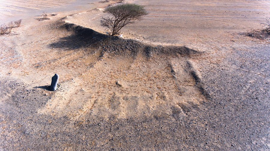
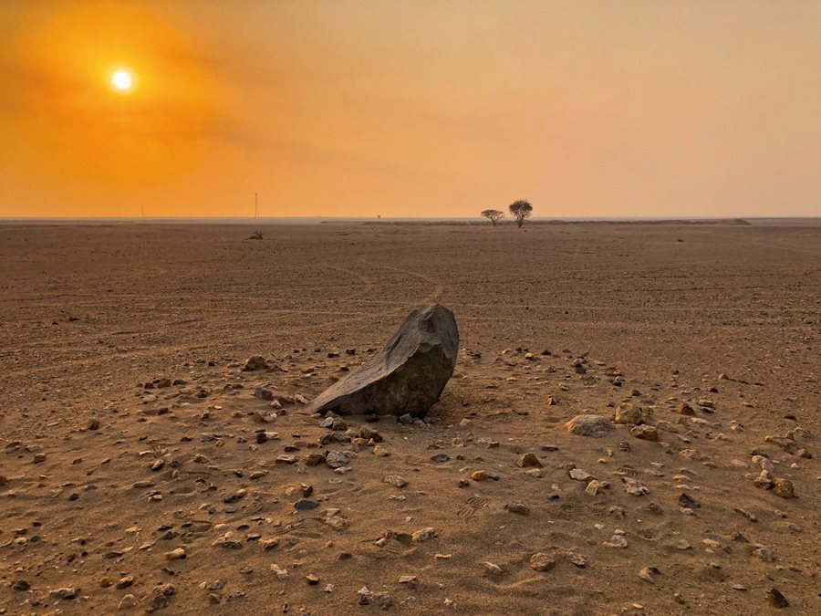
In the spring of 2005, to the side of a gravel track between rocky hills about halfway along the ancient caravan route between the holy cities of Makkah and Madinah in western Saudi Arabia, Abdullah Alkadi spotted a solitary, upright stone. About a meter tall, standing like a wind- and sand-worn sentinel, "it was clear that this was not there by chance," he recorded afterward. "The stone had been sculpted and purposefully placed there."
Alkadi was amid searches for historic sites that had connections to specific verses that appear in the Qur'an. He was focused particularly on those along the route of the Hijra, the migration in 622 CE of the Prophet Muhammad and his early followers from Makkah some 450 kilometers north-mostly along the caravan route-to the place where they would build the first mosque and establish the first Muslim community: Madinah.Alkadi knew that historical sources made references to milestones that helped travelers along this route, but other than boundary markers near the edges of the holy cities themselves, no such stones had yet been identified along the route, and the sources offered little in the way of description.
"Much of our work was conducted on foot," recalls Alkadi from his home in al-Khobar, along Saudi Arabia's east coast, where he has served as vice president of Studies, Development and Community Services at Imam Abdulrahman Bin Faisal University in Dammam as well as a professor at its College of Architecture and Planning. He holds a doctorate in urban and regional planning from Portland State University in Oregon, USA.
When he and his research companions found the stone, he recounts, they discovered with a bit of digging that about one-third of it lay buried, which had provided it the stability to remain standing for centuries.
Marking paths and roads with stone was practiced also along other desert caravan roads in the Arabian Peninsula. Most markers were cairns-conical piles of stones-rather than monoliths. The effort to quarry, carry and set this basalt stone clearly spoke to the significance of the task. Was it a landmark to help travelers follow the road? Or was it, as Alkadi hoped, also a distance marker?
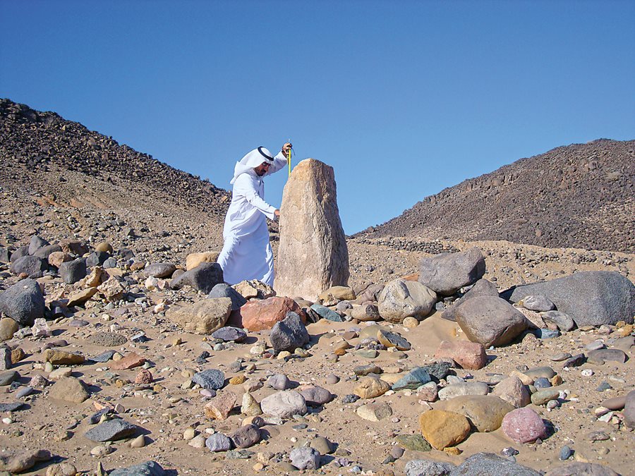
The discovery, he says, "triggered a 16-year, obsessive quest," involving more than 50 trips to segments of the caravan road and innumerable hours of background research and mapping "to seek out more marker stones and establish their significance and relationship to each other." This stone is now one of 63 milestones Alkadi has identified, and it is number 12 of the 55 recorded along the route in his book published this year in Arabic and English, Milestones of Arabia.
Babylonians, Egyptians and people of the Indus Valley all began to pave roads more than 6,000 years ago, but it was Romans who are first known to have used stones to measure off distances along them. Romans also gave us the mile, from the Latin mille passus-1,000 paces, counting one pace each time the left foot contacted the ground. (Each pace was equivalent to five Roman feet, and thus the Imperial Roman mile measured 5,000 Roman feet.)
Arabs used a similar word: mil, pronounced like a homonym for "meal." However, scholars have long been uncertain not only whether the mil's relationship to Latin is derivative or coincidental, but also how a mil was measured and how its distance was defined.
Like Egyptians, Sumerians, Romans and others, Arabs too used the human body for standards of measure: the width of a finger, a handspan, the length of a foot or a forearm, up to the largest unit, a full arm span. Four thousand arm spans was one way to calculate a mil, but a mil could also be counted off by steps, or by the distance an arrow would fly from a bow or, perhaps most intriguingly, by the distance the eye can distinguish a human figure on flat land.
Etymology helps here. Mil, explains Alkadi, comes from the root mayala, which means to lean toward something and approach it. One of its plurals is amyal, which is the word used historically for milestones in Arabic. This might indicate that the Arab mil was-at least in its origins-derived from references to visual distance. (Today, the Arabic word for "italics" is maa'il.)
Historical accounts extending back to pre-Islamic times, Alkadi found, offered distances for the mil that appeared to range from around 1,500 meters to nearly 1,800 meters. With this in mind, he set out to find more milestones along the Madinah-to-Makkah route, the road Muslim pilgrims and merchants historically have called darb al-anbiya, the Road of the Prophets: It is believed that in addition to the Hijra of the Prophet Muhammad, Abraham, Moses and Jesus also traveled this road, whose full reach extends north all the way to Jerusalem and south down the coast into Yemen.
"My hope was that if I could locate sufficient milestones, I would be able to survey distances between them and come up with precise measurements for the mil," says Alkadi.
He and his driver set off over the rough terrain, along the assumed route, using the odometer to approximate 1.6 kilometers, as today 1,609 meters comprises the statute mile still in use mostly in the US and the UK. The terrain became rougher, and so they walked. They found an intact granite stone, well off what seemed to be the track yet larger than anything around it, but this one had fallen. They kept going, and they found another. With three sequential stones, Alkadi later was able to measure and compare their precise distances from each other, and thus continue searching with more precision, working in an arc at a uniform distance-or a multiple of it-from each identified milestone.
In 2008 Alkadi enlisted aerial survey support from Saudi Aramco, which was using a light aircraft to plat land along the coast for the construction of the King Abdullah University of Science and Technology. But even the best geological mapping technology, it turned out, could not pinpoint individual stones. The focus returned to footwork on the ground.
To date Alkadi has located 63 milestones along the 430 kilometers of the Darb al-Anbiya between its historic end points at the boundaries of each holy city's haram, or sacred precinct, within which lie Madinah and Makkah. He surveyed, measured and photographed each stone standing, prone or part-buried; whole, split or in fragments. The distances between adjacent stones vary from today's statute mile of 1,609 meters by only a few meters. As for the 133 more milestones Alkadi expects once stood along the route but have not yet been located, he anticipates that he may yet be able to find about half of them-probably in fragments, entirely buried or both-and that the others will never be found, having disappeared due to removal, modern construction activity, flash floods or other vagaries of time, elements and human action.
Professor Saad Al-Rashid is a leading expert on the history of desert travel and a former deputy minister for antiquities in Saudi Arabia. In 2020 he published an updated edition to Medieval Routes to Mecca: A Study of the Darb Zubaydah Pilgrim Trail, the road that since the ninth century linked what is now Iraq to the holy cities.
Alkadi's work, he says, "is impressive in the way he has employed modern techniques and instrumentation to follow this ancient route between Madinah and Makkah and mark out stopping points and find milestones," he says. Some of these stones, he adds, are all the more interesting for the Arabic inscriptions and tribal markings they carry. "We can now look forward to further research to build on Dr. Alkadi's important studies and fieldwork."
For example, the establishment of the distance of the mil helps historians understand more precisely not only the locations of places mentioned in historical sources, but also the measures of other units of distance. Important among these caravan routes was the marhalah, equivalent to 24 mil. Alkadi points to the explanation of the term written by the 13th-century Arabic lexicographer Ibn Manzur, whose Lisan al-Arab (The Tongue of the Arabs) related the word marhalah to rahilah, which refers to a pack animal and alludes to when cargoes are set down for rest: in other words, a day's ride on camelback. Caravans were thus in most cases able to conveniently cover a marhalah before making camp for the night.
While such a practical standard of measurement was probably in use in various forms in other lands for millennia, with the coming of Islam in the seventh century CE and the codification of its canonical practices that followed, marked distances like mil and derived multiples such as the marhalah took on religious significances, too. The marhalah, explains Alkadi, "was used to determine the exact minimum distance the faithful could travel on a journey in order to be able to shorten or combine prayer. The distance would also make travelers eligible for other dispensations, including [exemption from] fasting in Ramadan." Alkadi goes on to explain that to earn such dispensations, travelers were required to be on a journey covering at least two marhalah in the same direction.
Alkadi continues to describe how a half marhalah, or 12 mil, was used in the late seventh century CE when Mu'awiyah, the first caliph of the Umayyads, who were based in Damascus, organized postal courier services using a system of half-day relays. The postal half-marhalah was called al-barid, and the word is still in use today to refer generally to mail services. "The postal stations were set up every 12 miles [19 kilometers] along the major roads of the expanding Islamic empire," says Alkadi. Each official courier would make his delivery to the next station and, that same day, return to his own station-a roundtrip, one-day journey of one marhalah.
Using the distance of the marhalah, the route from Madinah to Makkah was divided into 11 days of travel, with the last day being shorter by six mil.
"I was determined to locate the chain of milestones along all 11 marhalah," says Alkadi. The first stone discovered, which turned out to be 12th among the 55 he sequenced in his book, turned out also to lie along the sixth marhalah, which yielded more stones than any other marhalah: 21. Sometime between the ninth and 11th centuries CE, he explains, this stretch of the route was abandoned in favor of a more westerly track. Thus falling into disuse, the sixth marhalah truly become a road less traveled. Additionally, its location distant from modern towns and roads helped make its milestones the best-preserved of any part of the road.
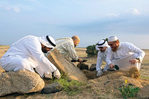
This does not mean they were easy to find. Some presented daunting challenges. Alkadi was determined to complete the sequence from milestones 10 to 30, but in 2016 milestone 29 was proving elusive. It took six trips to the area over the next two years, and each time, though armed with new data and multiple remeasurements, Alkadi found only small stones strewn on the surface, none larger than 20 centimeters across and none in any recognizable pattern.
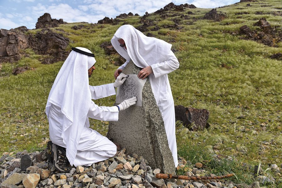
"We made a decision to dig around all these stones to see if we could establish one as a tip of a milestone. Ultimately, the patient surface excavations paid off with the find of a buried granite milestone which, when uncovered in 2018, measured an impressive 170 centimeters high and 60 by 45 in girth." Once the milestone was uncovered, measured and photographed, Alkadi says, "it was carefully reburied in its resting place."
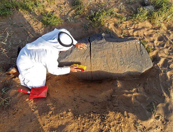
Its neighbor, milestone 28, an "angular, flat-surfaced slab lying in sand," was also difficult to find, but it has proven especially valuable for a two-word inscription at its tip that helped date the stone: khamsa mil (five mil). The reference to distance is not significant, Alkadi explains, but how it is inscribed: The letters lack the markings that came into use in the mid-ninth century CE that made each Arabic letter fully distinct. Other inscriptions on other milestones, too, use similar letter forms, and together they point to dates for the milestones not later than the first half of the ninth century.
Other stones he has found in fragments, Alkadi believes, may have been torn from their bases and smashed against other stones during flash floods. Throughout the mountains of the Hijaz-western Saudi Arabia-vast catchment areas can produce powerful torrents that rush down toward the Red Sea littoral along riverbeds that flow only in flood.
Along the last marhalah, which ends at the boundary marker of the haram of Makkah, Alkadi could not locate a single milestone. Similarly, along the first marhalah beginning at the haram boundary of Madinah, Alkadi found none until the second marhalah, where a milestone lies on the ground at the base of a tree 33 mil from the Prophet's Mosque. This absence of discoveries at either end of the route is most likely a result of disturbances from construction and various expansions of the holy cities over many years, and recently in particular, Alkadi says. Similarly, not a single milestone has been found along the fourth marhalah, and in the ninth and 10th, he located only one on each stretch.
In 2012 photographer Peter Sanders made the first of what would become three trips to join Alkadi and his team to photograph the milestones. "These were tough field trips, and they made a deep and lasting impression," says Sanders, who over 55 years has photographed Muslim lands and cultures around the world. From his home in northwest London, Sanders reflects that the milestones were placed "to guide pilgrims and wayfarers to their rightful destination," and that "with my senses heightened by being in the desert, and my vivid imagination, I sometimes would see bearded faces carved into some of the milestones. They became friends."
It may not be only Sanders who imagined such things, Alkadi says. The relatively human scale and proportions of so many of the milestones likely offered a kind of anthropomorphic reassurance to travelers in lands where comforts were few and risks were plenty. "They are remarkably similar in dimension to the human form," he says-even more from a mil or so away, at which distance they might resemble or evoke a fellow traveler. Some, such as milestone 17, even lean in ways that make them resemble a person walking, with the "weathered silhouette, viewed from either direction of travel, appearing remarkably human-like."
After so many years of letting one thing lead him down the road to another, Alkadi says his next steps will on the one hand take him deeper, and on the other farther. He looks forward to devoting more energy to excavating promising sites in search of further milestones and undertaking surveys of the southern extension of the trade route from Yemen and the northern route up into Palestine. The milestones between Madinah and Makkah-however many are found-he hopes will "encourage and convince government, laypeople, scientists and scholars to recognize the importance of [the] milestones. I know that beyond their unique historic value they can also contribute a lot to our economy," he says, especially "in terms of its touristic attractions and cultural legacy."
Al-Rashid too sees opportunities to develop experiential, cultural programs along this route as well as others. "These will enable people to travel and camp along the route by foot and on camelback," he says, and "feel the rituals of the journey. ...They will enjoy the magnificent desert and mountain scenery of the region and explore along the way. Making such trips will be educational and life-affirming experiences."
Alkadi also wants to support the restoration of fallen and broken milestones, that they may now serve as sentinels of history, mutely immortal friends to new generations of travelers. Each one, he says, is "one more piece to the rich mosaic of the history of the Arabian Peninsula."
Peter Harrigan is a contributing editor and writer for Aramco World. As founder and editorial director of Medina Publishing, he has authored books on Riyadh and Diriyah. He is also commissioning editor for Arabian Publishing whose recent titles include Across Arabia: Three Weeks in 1937 by Geraldine Rendel.
Peter Sanders is one of world's most prominent photographers of Muslim cultures. He has traveled the globe seeking images of the warmth and compassion of humanity for more than 55 years.
( Source: ARAMCO World )
 Live: Hajj 2026/1447


